Geodesy for your success

3D laser scanning
Construction services
Facility Management
Surveying and mapping
Monument preservation · Archaeology

The previous explanations of the advantages build the fundamental added value that is created by using our 3D laser scanning technology:

  • Flexible
  • Data-collection of entire facilities
  • 0-downtime even in hazardous areas
  • One-time measurement –
    multiple usage
  • Collision check
  • Realistic 3D-model
  • Problem-free export of the data
    for internal use

In addition to that the collection of 20 – 30 million co-ordinates account for high precision and incredibly detailed visualization possibilities. To achieve the same goal with the traditional method numerous workdays are needed, while the activities will interfere with the ongoing production. The result is a longer planning period with a higher price tag.

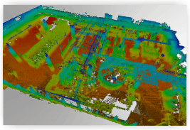
This is also the reason why, until today, an economical benefit of such a detailed model without the use of 3D laser scanning was impossible. Furthermore higher costs were the result during phases of expansion and reconstruction.

Additionally this method requested highly skilled geodesy engineers hence this technology is not nested within the competence profile of architects and machinery suppliers. On the other hand, 3D laser scanning replaces previous construction, planning and manual data-collection tasks at a decreased time-expense. Due to the fact that our method not only delivers a more precise, detailed and flexible final result, but also an increased cost-effectiveness, the economical advantage is obvious.

Use our service for decreased cost and increased competitiveness. The Geomatec team will also add value to your company.

www.geomatec.de