|
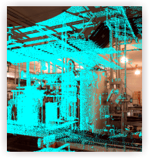
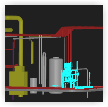
Oversimplified a laser is precisely scanning certain objects, rooms or entire production facilities including its machinery. It thereby recognises the contents and integrates the measurements into three-dimensional picture. At the same time a digital camera is used to create photogammetric illustrations. Those two components are afterwards used to construct a computer-aided model of the object. The final result is a three-dimensional, realistic replica of the original data source, which can be viewed from nearly every point and is dimensioned.
Due to that you will be able to have a virtual exhibition of your premises that can be adapted to changing machinery and floor plans. This extremely precise illustration can be used for immediate analyses and virtual changes within the layout and equipment.
|