Flexible ways of usage: e.g. documentation of current set-up, visualization of planning and control of implementation
Collection of data is done while your business is operating - no machine will be stopped, which means 0-downtime
Contact-free measurement, which can be used in dangerous areas (e.g. ATEX) without endangering humans, products or equipment
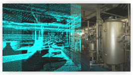
Geometric complete collection instead of single co-ordinates
Maximum distance of 250 metres (approx. 750 ft.)
Capacity of 20 - 30 million 3D co-ordinates per day - revolutionary cost-effective at maximum detail
Security of planning through higher density of information
One-time scanning gives the option to do all upcoming calculation within the 3D model
Realistic 3D model and visualization
Any imaginable point of view can be visualized
Precise measurements of masses and surface areas
Collision calculations with the additional data of e.g. machinery supplier
Easy use of data-export for internal use
3D model can be furthermore used for future additions